
Te Araroa part 18: A mixed bag (of oats)
As the title implies, this section of the TA was a bit of a mixed bag. There were many good things, like epic views, steep climbs and rivers to bash through. However, we also had more than our fair share of gravel 4wd tracks, tussocks and bogs. And oats. So. Many. Oats.

Leaving the splendid Ohau lodge
We didn’t really want to leave Ohau. It had been one of our favourite places to stay on the trail. I mean - hot pools and a bar, what’s not to like? But the TA must go on, so we made our breakfast oats and packed up. We didn’t really fancy walking 3 km on the road to get back to the trail, so we took a gravel path that was in fact the continuing Alps to Ocean. This joined up with the TA after an hour or two. This was plenty of time for me to realise that new boots, or trailrunners with new insoles, could not alter the fundamental principle that paths with gravel and large-ish stones are a real pain to walk on. Luckily we got a nice path afterwards. It climbed up through a beech forest (our first forest in who knows how long!) and we met up with Brianne and Yerin again. They had stayed with some trail angels in Ohau the previous night, a stay that involved fresh bread and philosophical discussions well into the night.

The bushline
Once we reached the bushline we still had a bit of climbing to do until we reached the saddle. We had lunch with Yerin, Brianne and Michael who we’d met at Ohau. From the saddle, it went downhill. Literally and figuratively. It started out as a nice enough descent, with some scrambly sidling bits above the stream. Then the valley flattened out. We met a couple of NOBOs who told us the trail was absolutely horrible. Our unofficial motto is “Never trust a NOBO” which again proved to be correct, because there wasn’t really a trail. And if there isn’t a trail, then it can’t be horrible, can it? There were about fifty different “trails”, most of which disappeared before we had taken more than two steps. The lack of marker poles was making itself felt. When you can see a line of marker poles in front of you, everyone will end up walking in the same place so eventually you get a trail. But when they’re too far apart everyone just randomly walks downstream. We eventually found a whole bunch of poles, lying neatly bundled beside on of the ten poles in the valley. Yerin was not amused. I wasn’t amused either. We tried to keep a steady rhythm going (easier for my feet) but every hundred metres or so we met some kind of obstacle that broke that rhythm. A patch of bog. A whole thicket of matagouri (that stabby pricker bush). We yelled a bit at the “trail” just to let some of the frustration and anger out. It didn’t help, obviously, but it made me feel slightly better. We camped near a stream with Yerin and Brianne. The moment the sun disappeared behind the mountain we put on all our clothes. This was going to be a cold night.

Approaching the Ahuriri
It was. The condensation on the inside of our tent had frozen. It was also Jasper’s birthday, so as a present to him I volunteered to shake out and pack up the tent. Yerin and Brianne had made him a birthday card featuring all the Dutch phrases they had learned, to which Yerin thoughtfully added a dead sandfly. Brianne promised to reveal her present in the evening. The three of us sang Jasper a birthday song while we jumped up and down to get warm. Then it was time to head down to the Ahuriri river: our biggest (and probably coldest) river crossing. We had a look at the “official” crossing place, marked by massive orange triangles. To us it looked like the worst possible place to cross. The river narrowed here, so the current was swift and there were some massive rocks in the way. So we strolled downstream for a minute and found a wider, calmer spot with a shingle island in the middle. Even here, the water came above our knees and it there was still quite a bit of current. Nothing too dramatic, but we decided we might as well link up and use the mutual support method to cross. We’d seen it on Youtube and were keen to give it a try. As Jasper is the tallest, we put him upstream. Of the three remaining Anti Wekaweka Squad members, I apparently have the best combination of height and stability, so I was downstream. We did a couple of practice steps, then headed into the river. It was easy to cross with four of us together, but both Jasper and I had to lean down a bit in order to hold on to Brianne and Yerin.

A braid of the Ahuriri

Yerin trying to leave the Ahuriri valley
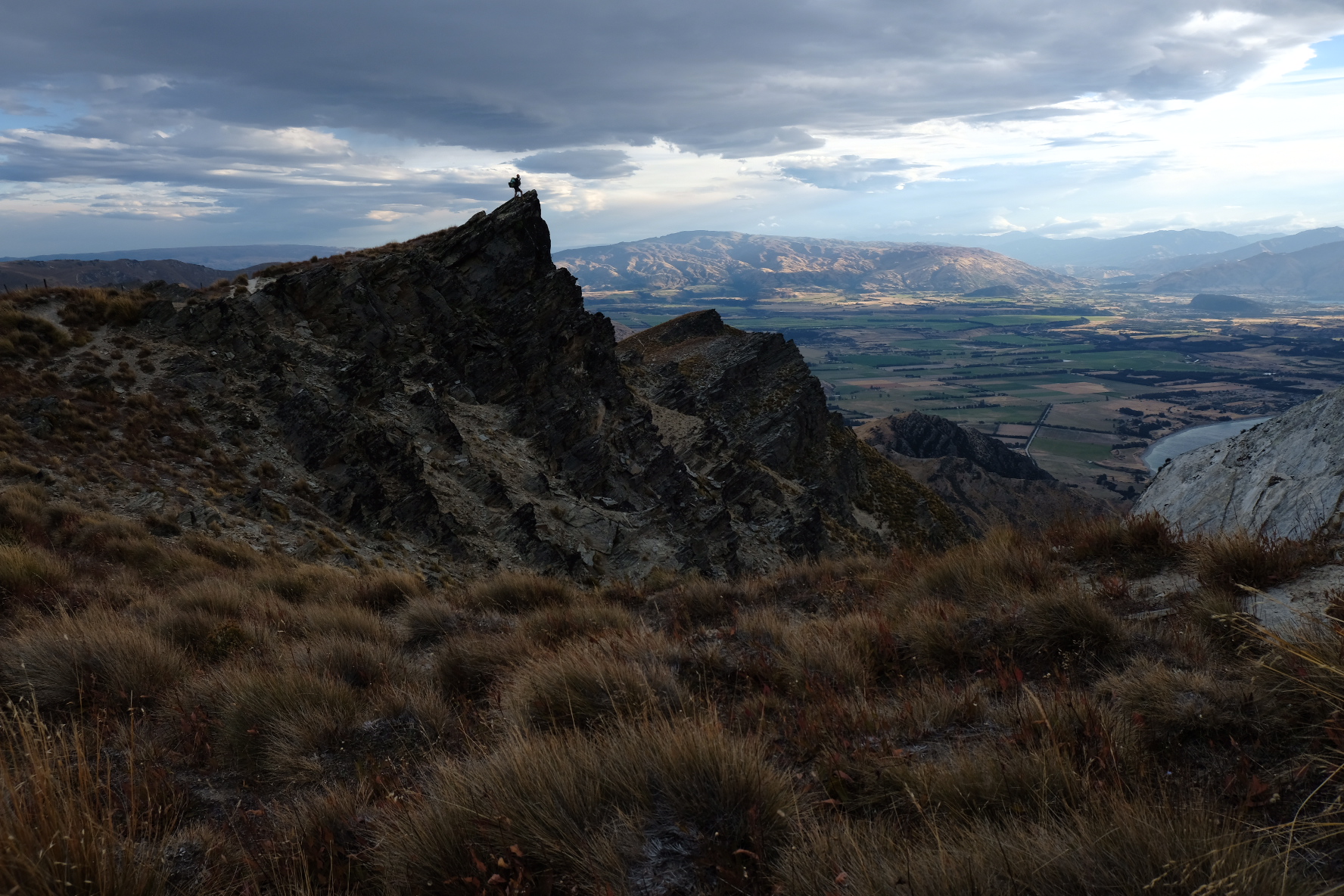
Once across the Ahuriri, we faced the next challenge: climb out of the river valley. This just might have been the steepest climb of the entire TA. The path went straight up a scree slope. The rest of the day was a 4wd track, but luckily not a very annoying one. There were no big rolling stones on it. However, it was still a 4wd track rather than a nice trail, and now that the sun was up it was once again becoming outrageously hot and there were no trees to provide shade. We soon passed by a collection of cow bones which someone had arranged so that they spelled “2500”. Nice and cheerful, and also in the wrong place. We were only at 2497 km! We figured it must’ve been made by a NOBO to mark 500 km from Bluff, and that some SOBO had come along and added the 2 later. The real 2500 km point wasn’t marked by more than stones with numbers scratched on them, there not being any dead cows around. Passing this milestone somehow seemed less impressive than passing the 1000, 1500 or 2000 km. Right, another nice round number. Big deal. After a lunch break at a small private hut containing a strange collection of comfy chairs, Jasper and I decided it was time for a bit of power walking. We cruised up the 700 m to Martha Saddle, from where we had a brilliant view towards the distant Mount Aspiring National Park. Jasper decided this was the perfect opportunity to take birthday photos.

A slightly sinister 2500km mark

Nearly at Martha’s saddle

Great views from the saddle
It was only a short descent to Top Timaru, a fancy hut. Fancy means it has bug screens on the window, so we could get some fresh air in without being eaten by sandflies. Even with the window open it was more a sauna than a hut but I guess it could’ve been worse. Michael was at the hut too, as was a German girl called Michelle. Brianne and Yerin must’ve told them it was Jasper’s birthday, because as we came in after a wash in the river, the four of them were singing “Happy birthday” and Jasper got to blow out the tiny stub of a candle they had lit. It was also time for Brianne to reveal her birthday present: a TimTam! Hurray! It was half molten from the heat but still recognisably a TimTam.

And down again, now towards Top Timaru hut
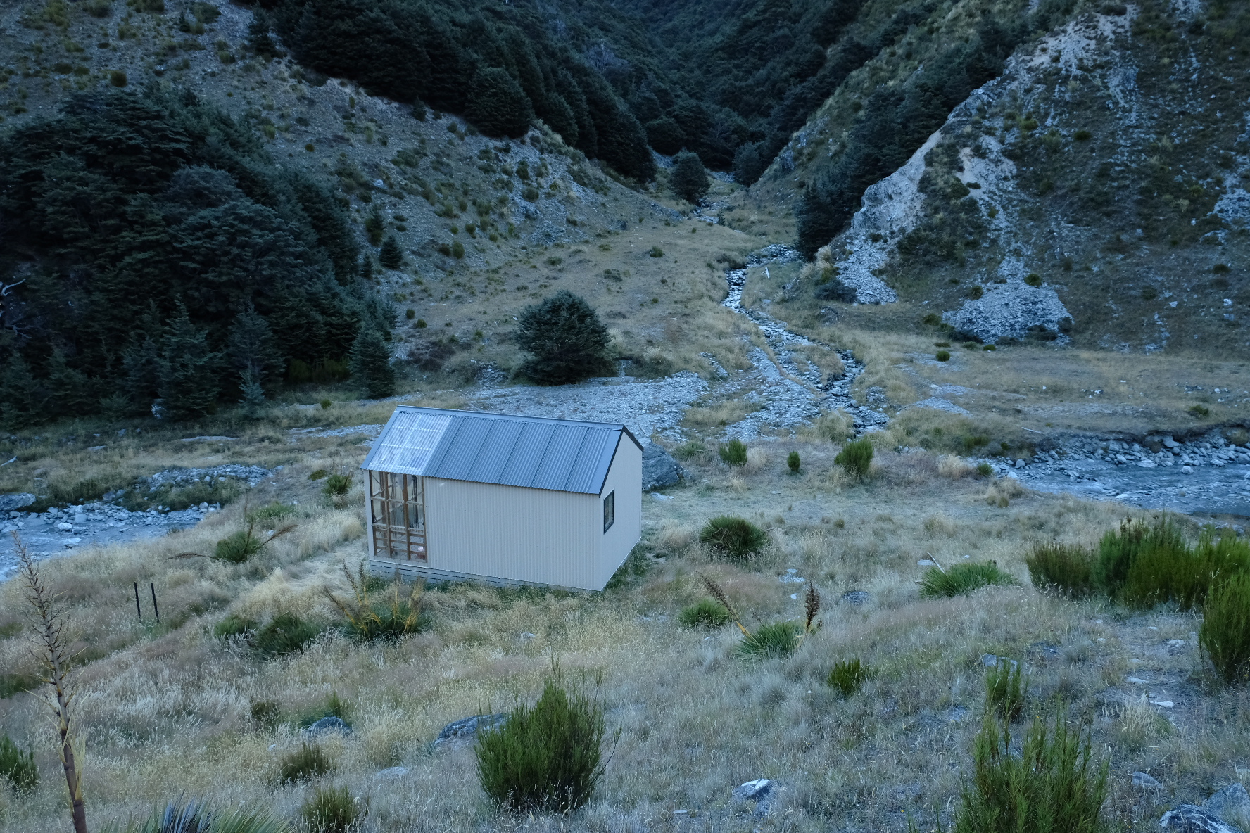
Cute little hut but fancy as!
We were up a little after sunrise the next morning. This late in the season, that means around seven o’clock. Definitely a lot later than a month or two ago. The days were becoming noticeably shorter, but rather than get up and start walking before dawn to do a long day, like Michelle and Brianne, we decided just to see how far we could get without any stumbling about in the dark. From Top Timaru hut, the track led along, above and through the Timaru river, with a dozen river crossings and lots of steep, narrow, sidling tracks and clambering over treeroots. Jasper, Yerin and I happily riverbashed our way along, scrambling over fallen trees and carefully making our ways across slips.

Some rocks

Crossing the river

Classic New Zealand track
We didn’t realise it when we left the river for the last time, just before the junction to Stodys hut, so we did not refill our water bottles and also could not be bothered to climb fifteen minutes back down again. So Jasper and I started the climb to Stodys with less than a litre of water each. Stodys is an old hut (one of those described as having “character”, i.e., a dirt floor and rats). We knew the water supply was a small stream and just hoped it hadn’t run dry. Man, we wanted that water. The climb to Stodys really was a climb. It was pull-yourself-up-by-the-trees steep. It was brilliant. We met up with Brianne at the junction, and the two of us enjoyed ourselves during the climb by telling each other about how good the tap water was in all the places we had ever visited (bottled water is an affront to humanity and should be banned). Just before Stodys we reached a small stream that was just big enough to refill our bottles, and this simple fact made it the best water in the world. After the climb, Jasper and I were sad to see the rest of the way would be flattish 4wd track. Sigh. Yerin and Brianne cruised ahead, as they always do on this kind of trail. It was getting late in the afternoon, but Stodys hut had even more character than we thought so we didn’t really want to stay there. So I ignored the stabbing pain in my arches and my squashed toes as best as I could (which was not very well, truth be told) and we continued walking. The views definitely made up for some of the pain though! Once we reached the summit of Breast Hill, we had a glorious view over Lakes Hawea and Wanaka in the fading evening light. It was also incredibly windy and we quickly abandoned our idea of camping at the summit. Luckily, although it was a steep downhill, it wasn’t far to Pakituhi hut, another fancy hut with bugscreens. This hut had been placed at the perfect spot, just behind the ridge, so that it had absolutely zero views. Shame, but you can’t have everything in life.

Bleak approach to Breast hill


The whole gang from Top Timaru hut had made it to Pakituhi. There were also three others. Mylan from the Netherlands was doing the TA NOBO and surprised us all by liking oats. Another of our unofficial mottos is “Fuck oats” because we’ve been eating them day in, day out, for weeks and weeks. Nothing, not cinnamon and dried cranberries or pumpkin seeds or M&Ms can make oats taste good to us anymore. But Mylan still loved them. She said she loved them so much that she had them for breakfast and lunch. Her bag of oats was almost the size of our entire foodbag. She had 1.5 kg of the horrid things. That’s ten breakfasts for me and Jasper. We asked Mylan to let us know when she finished them. It only took her three days. Three!!! Days! Impressive, but also terrifying. The other two new people in the hut were a Kiwi couple doing a three day hike. They were friendly enough but also stupidly lit candles. I woke up in the middle of the night to find them still burning, and had to clamber out of my bunk to blow them out. This was a lot more painful than it sounds: the bunks have little wooden ladders with narrow rungs which hurt like hell when you’ve got plantar fasciitis. In hindsight, I should’ve just whacked one of them with my pillow and made them go and blow the candles out.

You don’t get this view from the hut. You have to double back to the ridge at sunrise a bit
To cap it all, I forgot to tell them off in the morning because they left early and Jasper and I decided to take an easy day. As we were the last to leave, floor sweeping duties fell to us. We swept up more dirt than any hut could possibly have accumulated in a single day, which made us realise we were probably the first to sweep in quite a while. Ah well, we had the time. It was only a few km to Lake Hawea, though it was down a steep slope with loose sand and stones to make it more interesting. The landscape of steep cliff faces and rocky outcrops reminded us of the Vercors and Chartreuse in France. Annoyingly, this track ran beside a fenceline. Bits of old fence lay here and there on the track. Additionally, some of the posts were supported by steel rods acting as guylines, anchored into the rock. These supports were stupidly placed on the path side. This meant we had to scramble down the steep slope and climb over the rods at the same time. Despite the stupid fence, we had a lot of fun on the descent. Even though we started late, we reached the lake before lunch, and Jasper got chatting to some people on the beach. They were collecting rocks so they could build a drystone wall for their vineyard. Their vineyard was quite small so unfortunately they didn’t sell their wine anywhere, but they did give us a lift to Wanaka which meant avoiding 30 km of boring walking on flat ground. Hurray!

The approach to Hawea

Poor Philip...
Wanaka was crowded with tourists, and with people setting up stalls and fences for the upcoming agricultural show. This would include various competitions like horse jumping, but also a whole bunch of things like “most weirdly shaped vegetable”, stuff I thought only happened in Midsomer Murders. We were keen to buy tickets to attend this glorious event, but sadly it wouldn’t be until the weekend and we were not willing to take four zero days just to see an oddly shaped vegetable. Damn and blast. We would take one zero day, and one only (we really needed to do laundry). We had just found a spot at the local holiday park when we got a surprise text message: Jakub and Katerina, the Czech couple we’d met on Ninety Mile Beach, were wondering if we wanted to meet up. Of course! But we had thought they were far ahead of us. Turns out they had already reached Bluff more than a week earlier (legends!), and were now slowly heading back north. They had been keeping an eye our blog and had somehow deduced we must be near Queenstown by now, which I found impressive of them because I was incredibly behind with the blog (blog Marte and Jasper were still in St. Arnaud when the real us were in Wanaka). It was great fun catching up with Jakub and Katerina again and to hear about their TA adventures. This included a nasty fall that left Jakub with several bruised ribs, which apparently made lying down to rest quite painful, so they decided to just continue hiking instead. They had also heard from Pete and Karen and we finally learned about their time in the Richmond ranges: it was Karen who had fallen and badly injured her leg. A couple of DoC workers who were doing hut maintenance offered them a ride in their helicopter so she wouldn’t have to walk out or activate her PLB. After some time off trail, they had tried to continue hiking but Karen’s injury was slow to heal, so in the end they rented a car and decided to roadtrip instead. It was sad to hear that their TA had ended like this, but we were relieved that they weren’t badly hurt.

TA reunion!
The evening turned into quite the TA reunion, as more and more of our friends showed up. We should have known - we had plonked ourselves down by the food trucks and where there is food, TA trampers are never far behind. Marion and Francois joined us, and then Tom and Lana who we had met in the Richmond ranges. I hardly recognised Lana. She’d gotten a haircut and bought a summer dress, so suddenly she looked like a normal person. Tom was as PLB-less as ever, but he was wearing a suspiciously familiar pair of sunglasses. He’d found them on trail, and they were indeed the ones Jasper had bought in Methven and lost three days later. Ah well, finders keepers.

Beware... ducks...
The next day was a zero, which was spent planning our next section. Resupplying is getting easier and easier, because we pretty much know by heart what we eat on an average day. It’s just a matter of getting a supermarket trolley and plotting a good route from the chocolate aisle to the international foods and chucking stuff in as you walk past. But this time, we also had to plan the route we would take from Wanaka. Because we were going off trail again. Curious? I won’t say more here, except that the DoC visitor centre staff felt it was necessary to tell us our chosen route was very dangerous before taking our hut bookings and telling us the latest weather forecast and track updates. Yes, we know, we’ve seen the map. We are not idiot tourists.
We had time for one more beer with Jakub and Katerina, plus a hasty pie with Yerin and Brianne, who had been given all the leftovers from the bakery right before it closed. They were sitting on pavement with two others, munching their way through three boxes of assorted baked goods. Tramper trash, and proud!

#thatwanakatree