
Te Araroa part 19: Help, a parrot is eating my tent!
This part of our Te Araroa adventure was unique for not actually following Te Araroa at all. We went far off track, into the land of glaciers and tent-eating parrots that is Mount Aspiring National Park.
The TA follows the Motatapu track to Queenstown, which involves a lot of climbing and descending (yaay!), but on the same dry tussocky slopes that we’ve been seeing for weeks (boo!). We decided it was time to do something more alpine. And with Mount Aspiring National Park tantalisingly near, we picked the Cascade Saddle route, which we’d been wanting to do for years. It’s steep. It goes through magnificent alpine scenery. And people at the DoC visitor centre in Wanaka really really tried to discourage us from going there because “it’s dangerous”. What happened to safety being your own responsibility? We had read the DoC brochure and watched the movie they made (yes, seriously, there’s a little movie about the trail https://youtu.be/mAw50rnGoNU), and then decided that hell, yes! This was for us!
The first challenge: get to the start of the track! From Wanaka to the carpark at Raspberry Creek in the National Park is a 50 km drive. Normally it’s not a problem because dozens and dozens of people go here every day to do some of the easier hikes (like up to Rob Roy valley). But this day the forecast said crazy amounts of rain, although it was still nice enough in Wanaka. The first part of the hitch was no problem. A Latvian rock climber was going halfway to Raspberry Creek and was happy to give us a ride. He dropped us at a carpark, and we immediately realised the second part would be tougher. Dark clouds were swirling ominously above us, and there were very few cars. There was foot traffic though, and lots of it. We hade accidentally ended up on the route of Race the Planet, an epic 200-something km run through the mountains. It was the penultimate day of the race and some of the runners were starting to look a bit ragged. We got chatting to Megan, who was directing traffic with a Stop/Go sign, and joined her in cheering the runners on. Between runners, we told her about the TA, and she told us about all the races she had run, including one on Antarctica. Whoa! In return for our company, Megan kept the sign on Stop for as long as she could so Jasper could chat to the drivers and ask for a ride. And finally, once the last runner had past, and as Megan was preparing to pack up, an Australian dude let us hop in. It was cramped, because he had already picked up Brianne and Yerin. Good thing too. It started to rain, and we could see that the Australian was beginning to reconsider his plans for the day. But he was no match for four TA hikers happily chatting about how good the waterfalls would be. We cheered him on has he drove down the gravel road to Raspberry Creek. It worsened with every km and the guy was definitely a bit nervous about the fords. Without us, he probably would have turned around and never have discovered his epic driving skills on dodgy roads.

The Western Marukituki valley

Tramping in the pouring rain
Once at Raspberry Creek, we said goodbye to our driver and set off in the pouring rain. It had stopped drizzling. Continuous sheets of water were cascading from the sky. It wasn’t just raining cats and dogs, we were being pelted with a veritable zoo of animals both wild and domestic. Before anyone freaks out about us doing a steep and dangerous hike in the pouring rain: we weren’t. This day was just the approach to Aspiring hut. An easy two hours of flat walking on a 4wd track (sigh). We needed to be at the start of the Cascade Saddle route early next morning, so we just had to grin and bear it and get soaking wet. The advantage of getting soaking wet is that you can’t get any wetter so there’s no need to worry about any rain. The wind was still annoying though. Ever so often a particularly strong gust would make us stagger sideways. Yerin, the smallest, was regularly blown off course. This made dodging cowshit on the track a bit difficult but we arrived at the hut without any major mishaps. Our DoC hutpasses were not valid at this hut, and it cost us 30 dollars to stay here, but man were we glad for this hut! Two Americans and a Kiwi mountain guide had gotten there before us and started a fire, so we could dry out a bit. We made hot drink after hot drink, and drank the surprisingly good whisky that Brianne had bought in Wanaka.

Trying to dry our stuff

Some Dutch courage (i.e. alcohol)

Up up up we go

Through the forest
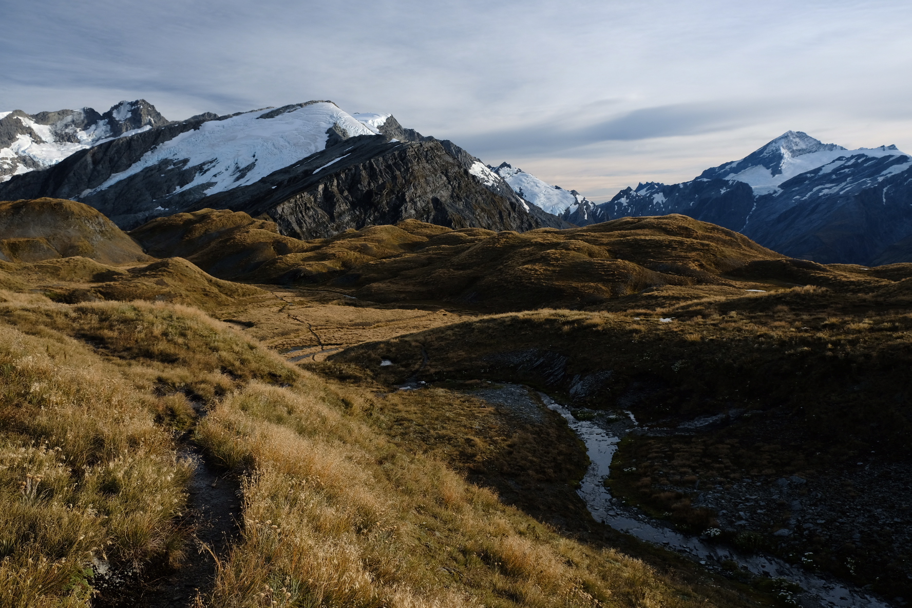
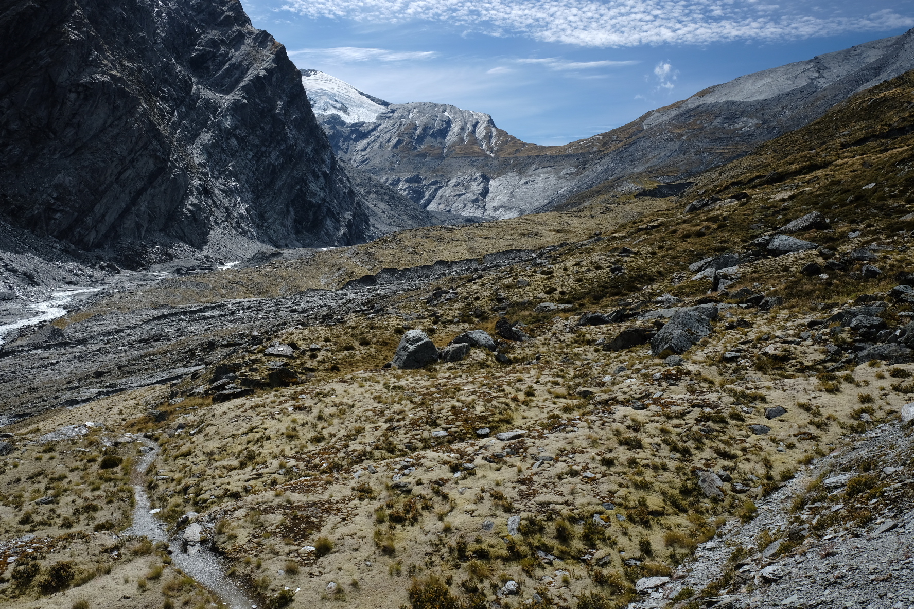
The weather forecast promised that the clouds would part and the sun would shine the next day. By early morning, the clouds still hung motionless around the tops. It would probably take a few hours for us to climb to the treeline and by that time the sun would surely have broken through! Nope. All that happened after two hours of steep climbing was that we entered the clouds. So far, the trail had been steep but very good. It was quite broad, it wasn’t muddy, and there seemed to be a trailmarker on every other tree. But we had also passed a few warning signs which told us to turn back in bad weather, and warned us that multiple fatalities had occurred, and the trail was not worth our lives. We knew that the snowgrass above the treeline was very slippery when wet, and with everything still dripping from the rain, this might be interesting. We continued carefully, but as yet there was no need to worry. Yes, it was steep, but the path was broad enough so we didn’t have to step on any snowgrass. There were one or two rocky parts that were slightly uncomfortable because they required some sideways scrambling and bigger steps that my legs couldn’t easily do. Other than that, it was fine. Just steep. We kept going through the fog. At some point we met the Americans and their guide coming down again. They said it was foggy at the top too, but that didn’t deter us. The forecast said it was going to be sunny, so that sun better be up there! The clouds actually parted very slightly just as we reached an epic viewpoint, consisting of a rocky ridge with sheer drops on each side. Far beneath us was the Matukituki valley that we’d hiked through in the rain on the previous day. After this tantalising glimpse the fog was back, so we scrambled on. Not long after we reached another sign, this one warning us that the most dangerous section where everyone had died lay ahead. Surprisingly, we all felt that this part of the trail was easier, if anything, than what we had already done. When the path flattened out we hardly believed we were on the summit already. But we were. A small pylon marked the highest point of the route.

The forest is getting foggy

A steep bit

A glimpse of the view below

Dramatic moment
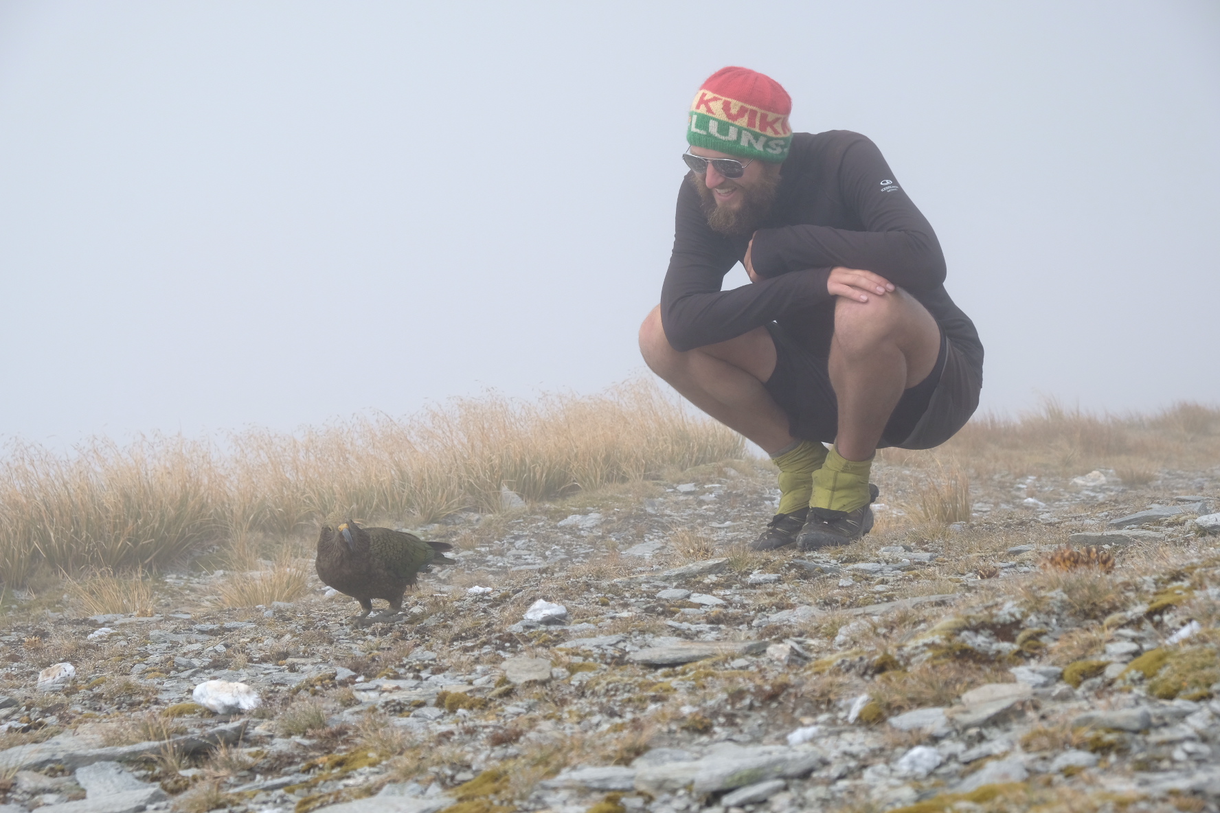
Kea!

Kea?
Still there was no sign of the sun. But we were not going anywhere without seeing those views, so we took a five hour lunch break in the fog. Brianne huddled in all her clothes, while Yerin and Jasper set about to build a massive cairn to mark the summit better than the wonky pylon. I alternately dragged stones for the cairn, and huddled with Brianne. From somewhere in the fog we heard the unmistakable sound of a kea, the world’s only alpine parrot. As I’ve said before, it’s Jasper’s favourite bird. They’re incredibly intelligent and also like to wreck stuff. We hoped they would come closer, and as a precaution packed away all loose edible items. One or two kea did indeed land in front of us, and while we were excitedly watching them, a few more approached us from behind with what I have no doubt were snack-stealing intentions. Nice try, birds, but we’ve all seen Jurassic Park. More and more kea came to keep us company, until we had nearly a dozen flapping, hopping and squawking around us. The kea provided welcome entertainment while we waited for the stupid fog to lift. Occasionally, we caught a glimpse of a summit, glistening with snow and glaciers. And then suddenly the fog disappeared. The sun shone down from a bright blue sky. Below us was the Matukituki valley, with the dramatic peak of Mount Aspiring opposite us. On the other side were rows upon rows of sharp peaks and a magnificent glacier. We did what the Anti Wekaweka Squad always does when arriving at a spectacular location like this - we took dozens of epic squad photos. And photos of the view. And of the kea, that were still flapping about.

The fog is lifting

Kea rap album

Those wings though!

Squad photos

One hell of a panorama
As it was now quite late, we decided to camp. About an hour after the pylon there was a longdrop and a flattish area which was the DoC-recommended campsite. As the sun disappeared behind the mountains the temperature dropped rapidly, and we put on longjohns and puffy jackets. We pitched our tents there, together with a German guy who had been hiding nearby in the fog. Two Kiwi trampers had likewise been lurking in the fog. They were going to camp further down, near the saddle. We hoped they would take the kea with them. Fun birds, but they wreck tents. So as we pitched our tents we did our best to kea-proof them. They would probably go for shiny objects, we reasoned, as we stacked rocks over our pegs. And all our food would be in drybags in our backpacks which we put under the fly, but outside the sleeping area. Would it be enough? Would the epically snack-crazy and destructive parrots leave us alone?
Nope.

It’s completely frozen
We were woken before sunrise by a yell from Yerin: “There’s a kea! It’s attacking my tent! No! Go away!” Just slightly ruder. Her shouts were answered by an inquisitive squawk from the bird in question. It was trying to pull away the foil blanket that she was using as a groundsheet for her tent but also seemed very curious about the noises emanating from the tent itself. Judging from Yerin’s shouts, the bird had poked its head under the fly and was now checking out her boots. Jasper and I disentangled our frozen limbs from our quilts and stared at our own tent in the gloom. It looked intact. We breathed a sigh of relief that the kea didn’t really seem interested in the Palace. Brianne was not so lucky. She had a foil groundsheet as well, which the kea soon discovered. With both our hiking companions now fending of attacks, we decided we might as well get up.

Frostbite
It was cold and the tent was frozen again. I taught Jasper the Norwegian technique “floke” and soon he was jumping up and down, flapping his arms. He was also wearing his Kvikk Lunsj beanie. I think this was the moment that Jasper finally discovered his inner Norwegian. All this warming up was a little bit useless because within two hundred metres we had to cross our first stream. I decided to keep boots and trailrunners dry and did it barefoot. So. Bloody. Cold. But not very deep so it was fine. The short climb out of the stream valley warmed us up nicely, and as we approached Cascade Saddle itself the sun came out and it was time to strip off all our layers.

Cascade stream is cold as!
Approaching the saddle

Epic morning light

Living on the edge
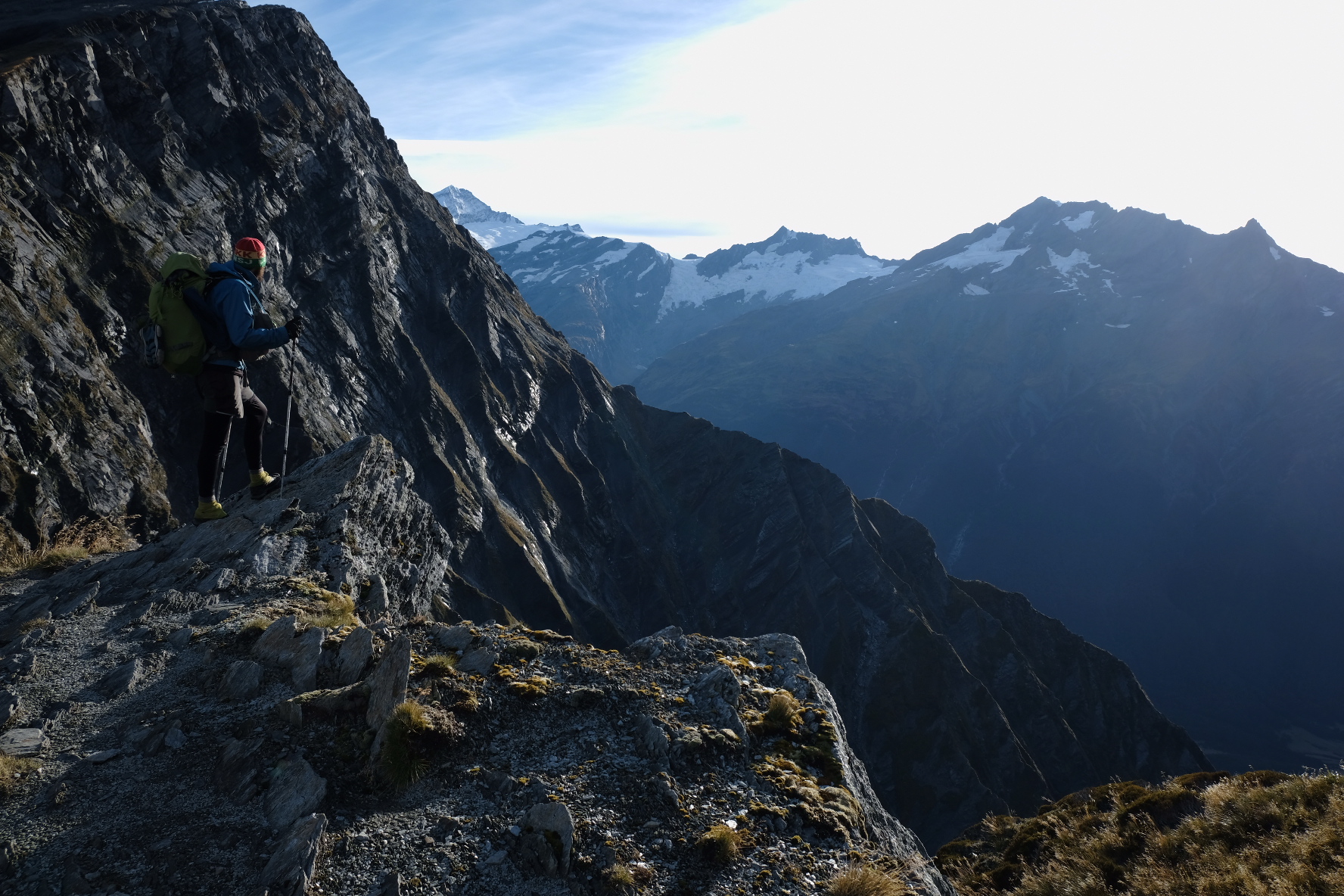
Edging closer

Looking back to the Matukituki
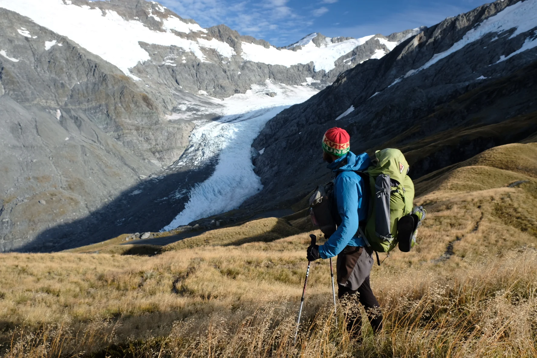
Brianne had been eyeing the sheer drop from the saddle. Her dearest wish was to sit on the edge and look out over the Matukituki valley with just air beneath her feet. And what a view! In the early morning light everything shone. We descended towards the Dart valley, taking our time so we could savour the landscape. Glaciers are always impressive. Now we were right above the Dart glacier and could truly appreciate its vastness. We saw more kea as we went down the valley. One posed for photos on a rock with the glacier behind. A few stream crossings and some easy walking later, and we arrived at the Dart hut. We’re used to the poky old musterers’ huts that dot the TA, so the Dart hut just seemed excessive. It wasn’t a hut but a village, consisting of several buildings, covered outside areas, and even flush toilets. It was also completely empty. We sat inside having our lunch, then decided we might as well continue and do some more hiking.
Dart from above

Dart from the side

Dart from a bird’s eye perspective

Dart from behind
Darting back
Dart hut is in the middle of the popular Rees-Dart circuit, a four day hike which links the Rees and Dart valleys. We decided to continue through the Rees valley because we knew there were jet boats on the Dart and jet boats are really annoying. And going out the Rees meant another climb up Rees saddle, which separates the two valleys. We were now on a tramping track rather than a route, so we expected the trail to become fancier. It did, to some extent. The streams were bridged, but otherwise there wasn’t really an improvement in track quality. In some ways the track became worse: our old foe, speargrass! We climbed steadily up to the saddle, enjoying the views back over the glaciers. The descent from the saddle was nice and steep, and after some more speargrass-dodging and occasional bog-hopping in the Rees valley we approached Shelter Rock hut. This fancy hut was our home for the night. We chatted with a guy who had recently finished the TA and was doing the Rees-Dart to gradually wean himself of hiking. That might be us in just a few weeks...

The Rees saddle is on the right

Snacks are life, also on Rees saddle
The next morning we found an unpleasant and rather smelly surprise. Person A had left their trash bag in the hut. Person B had added a little note, explaining that they were still going to be hiking for two or three days so they didn’t want to carry it out, and asked someone else to do it. Judging by the smell, this bag had been there for a few days and persons C, D, E, ..., X and Y had decided it was not their problem. I became person Z. We strapped the bag to the outside of my pack and hoped it wouldn’t burst. It did about an hour later, and smeared fishy goo on the outside of my pack. Ugh.
Long exposure waterfall

Dramatic views of the waterfall
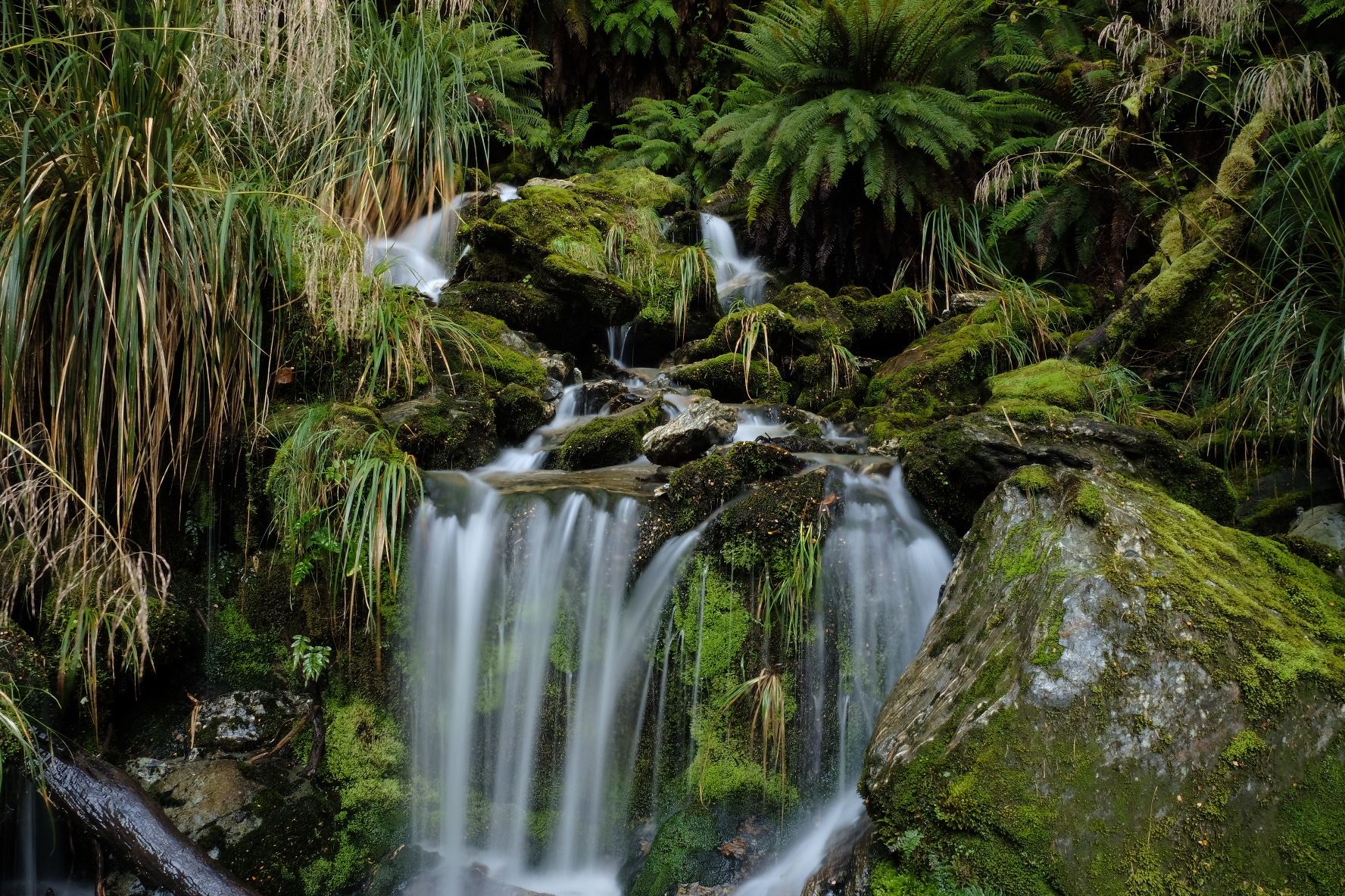
Despite a rather smelly start to the day, we were soon tramping happily outside. There were some great views back towards the glaciers, and stretches of beautiful forests. Streams cascaded down from the mountainside, and because this was a well-known tramping track, they were bridged! After a few hours of this pleasant walking we reached the borders of Mount Aspiring National Park and entered the Rees station. At first this was pleasant walking across grassy valley flats, but soon the terrain became boggy. I had already developed a love/hate relationship with my boots, which became more and more tilted towards the “hate” side. The damn things aren’t fully waterproof! As far as I can tell, the area under the laces has patchy waterproofing, and as I walked and jumped my way through the bog I could feel water seeping into my boots. Great.

Lower Rees track: here be farmland
After some boghopping and some steep floodtracks over the river, we reached the carpark at the road end. We had planned to hitch into Queenstown from here and were a little bit freaked out to see only two cars and no people in the carpark. We knew that one of the cars belonged to a person we’d met at Rock Shelter hut, and that this guy would be tramping for three more days. Turns out most people get a shuttle transfer from Queenstown to this carpark, and back from the other end of the Rees-Dart. Oops. We had a quick lunch (inside the inner tent of the Palace, to keep the sandflies at bay), and then we grudgingly started walking down the long gravel road towards Glenorchy.

The best lookout point from the road
Just as we started walking, a trailrunner came whizzing past. It turned out he’d been running with a friend, but the friend was too tired to carry on. So this guy was going to run down the road to get his car, then drive back to pick his friend up. And he promised that if we were still walking then, he would cram us in somehow. Hurray! Bolstered by the thought of a guaranteed ride (even if it took an hour or two) we carried on. Not half an hour later we all jumped as a car drove up behind us. It was the second car! The two French climbers in it had already picked up the trailrunner’s friend and were happy to take us as well. We squeezed in somehow, with Yerin and me on the tiny foldaway seats in the back with our packs on top of us. A whole swarm of sandflies tagged along too and drove us mad the entire journey. With the packs in the way, we could not reach them as they bit our legs. Still, it beat walking 15 km to the main road. The French guys dropped us just before Queenstown, from where it was a short and easy hitch to the town centre.
The four of us got the last “bach” at the holiday park, which turned out to be a tiny cabin with bunkbeds rather than an actual holiday house, but it did come with sheets and towels. Real towels are a luxury. I wish some outdoor company would invent a lightweight quick-drying towel that feels like a real towel. But I’m pretty sure this ranks above the Grand Unified Theory in the list of “Very difficult problems that humanity should solve”. We did our resupply for the next section, and then Yerin and Brianne decided to cook. Jasper and I on the other hand braved the queue outside Fergburger, which was totally worth it (crispy spicy tofuburger, mhm!). Burgers are life.
Philip!