
Te Araroa part 7: Limping home for Christmas
The story so far:

The gnarly woods
Our intrepid heroes have faced mud, sand, rain, killer cows and hiker’s hunger. Now, after a daring traverse of the thorny slopes of the Forest of Death, they are huddled in their tent. They’ve got a pack full of snacks, it’s dark and they’re nursing a swollen ankle.
Is the ankle broken? Is this the end of their epic tramping dreams? Can they make it back to civilisation before the possums tear the tent apart to find the cheese crackers? Find out, in this next instalment of “Bob & FzbL: knocking about in the wild”
Okay, I won’t leave you in suspense any longer. The ankle was not broken. I won’t say it was fine because it wasn’t, but the TA could go on. After some not very clever decisions the previous evening, we decided to be sensible and walk the 10 km back to Te Kuiti rather than another 10 km on the Path of Horrors plus an entire day on gravel roads. As we were drying out our tent in the morning sun, Carmen and David came struggling down the path, muttering about how easy it would be to slip and fall here. They weren’t wrong! We met a couple of other trampers as we headed back to civilisation. They all greeted us with cheerful cries of “Hey, NOBOs!”, and then offered painkillers and gave advice on where to stay in Te Kuiti once they heard why we were going “the wrong way”. It took four or five hours to walk/limp back to Te Kuiti (aka the sheep-shearing capital of the world). The hostel was a few km out of town but luckily they offer pickups from town so I did not have to limp uphill in a thunderstorm. I spent the rest of the afternoon with my ankle on a chair. I believe the relevant acronym is RICE - rest, ice cream, elevation.

Hut in bog
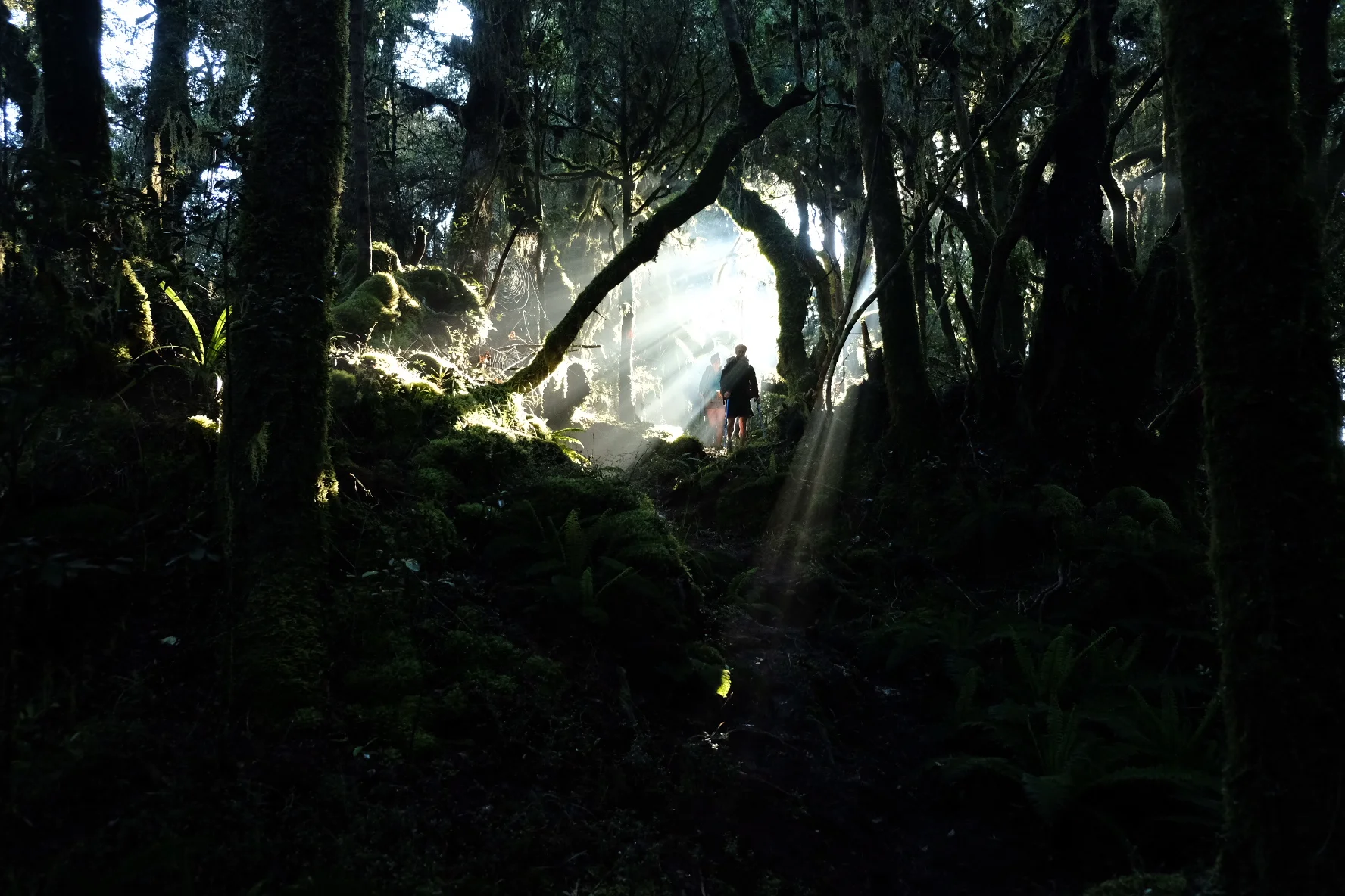
We decided not to risk another go in the Forest of Death. It’s one of those things that everyone should do once. Once. So we decided to do a bit of hitchhiking to get to the start of the Timber Trail. Emma from the hostel dropped us off just outside of town. It took us a surprisingly long time to get a ride, because it was Saturday morning and there was no traffic. We got lucky eventually, and arrived at the start of the trail around lunchtime. It’s called the Timber Trail because it passes through areas that used to be logged quite heavily. For some decades now, the forest has been protected and it’s slowly regenerating. Pockets of old forest remain, especially in the northern part. It’s without a doubt one of the most beautiful forests we had seen so far on the trail, with towering trees draped in moss. The trail itself was also a joy. No treeroots, no knee-deep mud and no steep rocky bits that require one small step for Jasper and one giant leap for me. It was wide, smooth and well-graded. In fact, many people cycle it. We stayed overnight at the Bog Inn hut, which is very aptly named. We had to go a bit off trail to reach it and that little side path was decidedly muddy and ended in a patch of bog. Carmen and David were already at the hut and gleefully informed us that we would be sharing the hut with many friends. These friends of David’s turned out to be mice. We figured that if they were David’s friends, they were more likely to run over his face than ours in the middle of the night, so we cheerfully grabbed the top bunks. Two others were camping just by the hut - a father with his seven year old son. This kid was going to hike Te Araroa in sections, starting with the Timber Trail. They were great company, not least because the father read Harry Potter as a bedtime story. He had a great British accent and did an excellent Lockhart.

Spot the 24 mice in this picture
Glorious morning light

Swing bridge
No mice ran over our faces during the night (or if they did, they didn’t wake us so that’s fine). The path back to the main trail was muddy but short, and we were soon back on the main Timber Trail. My ankle was still a bit painful but I could manage the fancy trail easily. The forest was changing. We soon left the old forest giants behind and reached woods that had been logged. The trees were a lot smaller and younger. We found that this diminished the beauty of the forest a bit, but to make up for that the trail crossed dozens of suspension bridges. We did 20 km before lunch, and then decided to push on to reach another campsite a further 15 km down the trail. Not bad on a rickety ankle! We were the only ones at our campsite, where we enjoyed a marvellous sunset that was made truly spectacular by floating dust/blossoms/somethings that sparkled in the fading sun. On our third and last day on the Timber Trail, we followed old logging tram tracks which included an awesome tunnel and spiral. We also crossed the 1000 km mark! This milestone was celebrated with a rather crumbly and molten Kvikk Lunsj which had been squashed at the bottom of one of my snack packs since Cape Reinga. I wonder whether Freia is interested in some form of sponsorship contract. We’ve got Kvikk Lunsj buffs and beanies, after all, and we’re spreading the joy of Kvikk Lunsj all across New Zealand.

Dramatic skies and floaty bits

Celebratory Kvikk Lunsj
At the southern end of the trail was a campsite put in place for TA trampers - without a doubt the best grass we’ve camped on so far on the trail. We were soon joined by a group of other trampers who had found the Timber Trail so easy that they did the thing in two days. Myriam, Adrien and Cosimo had been hiking on and off together for a while. We realised we’d met Adrien before when he asked after the ankle. He was one of the people offering painkillers and accommodation advice as we limped back to Te Kuiti after The Fall. We all made our dinners together and nerded about Aarn packs with Myriam, who’s the only non-Kiwi we’ve met so far with an Aarn. Hiking into Taumarunui the next day was a breeze. It was a full 26 km day but it was on nice gravel roads, the weather was beautiful, we had an ice cream break in the morning, and Myriam caught up with us pretty quickly and set a good pace into town. She usually does long days and tries to do 25 km before lunch. We think 25 km is a nice distance to hike in a day, with five snack breaks plus one longer lunch break. Still, we kept up with Myriam and did indeed arrive in Taumarunui in time for lunch: massive burgers and chips from the Golden Kiwi Takeaway. Delicious. Cosimo and Adrien joined in, and the five of us decided to stay together at the bach at the holiday park. Taumarunui holiday park give TA hikers a nice discount, free laundry powder (in their interest as well, we smell), and free pickups from town. While we waited for our pickup, we suddenly heard a cheerful cry of “oh tui bird” behind us. Sarah had decided to take a rest day in Taumarunui so we had caught up with her! Hurray! This really made our day and we made plans to hike together the next day. The holiday park was pretty amazing. We had a swim in the river and binged on snacks. We asked the others whether they have tried mint slices yet. Myriam had heard of them from someone. This someone turned out to be none other than our Kiwi friend Courtney. Who else? So we did a little photoshoot of the three of us with Aarn packs and mint slices to send to Courtney. Because we had just been swimming we were all in our swimming gear (aka underwear) which I think makes us officially tramper trash. Hurray!

Très charmant

U wot m8?
Our three new friends were taking a zero day in Taumarunui to sort out their upcoming canoe trip, so they had a bit of a lie in and were all fast asleep when we left the next morning. We met up with Sarah at the iSite and hiked together with her for the entire day. She said she was very pleased to walk with us again because the people she had been hiking with since Hamilton did not take snack breaks and were not into snack-sharing. Other than that, they were very nice people. Seriously though, how can you not take snack breaks?! To make up for the lack of snack breaks in Sarah’s recent past, we took about five that day. We also made friends with an ostrich and played some more black stories. We pitched our tents at the start of 42 Traverse. There was a lovely camping spot just by the Whakapapa river near Owhango. Sarah and Jasper did some scrambling to get down to the river itself. I decided not to risk the steep rocky descent with my ankle and instead crossed the river and took the well-made path down. My ankle may be wrecked but I’ve still got good eyesight. Sarah’s new friends showed up not long after us (if you don’t take snack breaks you can arrive early at the campsite after a 26 km day even if you get up at nine and lose the way before even leaving Taumarunui). Our dinner was slightly sad because we had less gas than we thought so the dehydrated peas were on the crunchy side. The tomato soup packet we added for flavour was too strong, and to cap it all it began to rain. So we spent a lovely evening in our tent, which is more than large enough to hang around in for a while. Both Jasper and I can sit up in it, while we inflate our mats and try to get our ultrafluffy and extremely large sleeping bags out of their compression sacks. Also, Jasper can actually lie down inside it without touching the ends with either his head or his feet. There’s a reason Courtney has named our tent The Palace.

We set the alarm for 5 am the next morning, because the 42 Traverse would be a 35 km day with some sections that could be “very muddy” in wet weather. The forecast: rain. Hence the early start. We planned to start around six, together with Sarah, but we had only gone about 20 m when our progress was halted by the sight of a pair of blue ducks on the river. Blue ducks! Whiooooo! These are awesome ducks that ride rapids. They’re super rare, even rarer than kiwis and they only live in swift-flowing, clean rivers. After this slight whio-delay we trudged on. The first part of the trail was on a mountain bike or even 4wd track so we made reasonable progress despite the rain. Lots of blackstories, which somehow all involved people named Fred and Alice. Around midday, we left the 42 Traverse and continued on the Waione-Cokers trail which was a lot rougher. Parts of it were badly overgrown and there were some steep muddy parts where the trail seemed to follow an old, washed-out streambed. We crossed the Mangatepopo stream and got a lovely surprise: an entire family of blue ducks, with four or five ducklings! They were just cruising downstream. We felt so extremely lucky to see blue ducks, not once but twice in one day! Whioooooo! The blue ducks were followed by brown sticky mud before we reached the road. Or so we thought. We knew we had to turn left at the road, so left we went. In the distance, we saw the other hikers so we thought we were on the right track. Funny, we thought it would be a sealed road, not a 4wd track. The track got rougher, and rougher, and wetter. Ok, time to check the gps. Turns out we should’ve gone right on the 4wd track which would then have joined the road after 50 meters or so. And that’s where we should have turned left. Oh well, no harm done. Once on the correct road, we hiked the last stretch with Sarah. She then decided to camp near a stream, while we continued to the holiday park (hot showers!) a bit further down the road. We were met by some familiar faces: Iben was there, and Valeria, who we had briefly met at Utea park on the night before we went to Cape Reinga. They had been forced to take a zero day because of the weather which had been so nasty that many of the tour buses to the start of the Tongariro crossing were cancelled. Our tent, shoes and socks were sopping wet but we pushed the coat rack in our tiny cabin over the radiator. The result: dry socks and a lingering smell of wet wool. Glorious!

Whiiiiiioooooo!

It’s a volcano, stupid!

Obligatory “one doesn’t simply waddle into Mordor” joke

“Dr. Van der Linden, I presume?”
The alarm went even earlier the next morning. The Tongariro crossing is one of the must-do hikes in New Zealand, so hundreds of tourists do it every day. Some have proper shoes, windproof jackets and sufficient food and water. Others wear sandals and carry a water bottle and a muesli bar in a plastic bag. Even these idiots sometimes make it across because it’s only a seven hour hike and the path is well-maintained. In that sense, it’s not hard, although the weather can get nasty and you are nearly 2000 m above sealevel without any form of shelter for about half the walk. We do that all the time in the Alps so the crossing didn’t faze us. However, we would have to do another two hours to get to the trailhead, plus another 10 km after we reached the other end of the trail. So another 35 km day, with lots of ascent. Hence, we got up before sunrise and were walking around 6 am. We love a good climb though, and I would rather do ten Tongariro crossings than one day of roadwalking. We made reasonable time on the roadwalk and then absolutely smashed it on the climbing section. We usually knock a bit off the estimated time on climbs and we were on good form - I think we knocked about a third off. The path was so well-maintained and smooth that you could probably get a wheelchair up there. Then obstacles started to appear. Most people hike the Tongariro crossing from south to north (Mangatepopo to Ketetahi). However, as SOBO TA’ers, we go the other way. I think north to south is the best way to go on the crossing. You get better views, and Mangatepopo is higher in elevation than Ketetahi so you get more ascent than descent. Funnily enough, the recommendation to hike south to north is because there is more descent than ascent that way. I’ve yet to meet a hiker who prefers descending to climbing. Anyway, the daytrippers - from well-prepared tramper to idiot in jandals - all go south to north so we met every single one of them. Gah. The first appeared around midmorning and by noon we were elbowing our way through hordes of tourists. Some politely moved aside for us, some muttered under their breath about “idiots going the wrong way”, and some stopped for a chat which is always nice. The DOC rangers immediately recognised us as TA walkers. The wind picked up as we crossed the Central Crater. We mentally counted the different sorts of hikers we saw: people in jeans (dozens), people with packs so tiny you wonder why they brought them at all (about fifty), people who were freezing despite obviously wearing all their clothes (most of them), people bringing their babies (only one, luckily, but one too many). I was still wearing shorts and my top because I knew there was another climb coming, and despite who knows what windchill I always get warm climbing. I got some funny looks though. Once at the top at the Red Crater it was on with the baselayer, jacket, mittens and hat. One woman asked us if we were Norwegians. How could she possibly have guessed that, thought Jasper, completely oblivious to our woolly hats that make us walking billboards for Kvikk Lunsj. We descended quickly because the weather did not encourage extensive hanging around. Once across the South Crater we had a late lunch break out of the wind. Suddenly the landscape around us was empty. The buses unload the last tourist hordes before noon so even the slowest people have a good chance of getting across before dark. We had made it through the bubble, and only met the occasional hiker from this point. One guy who had climbed Mt Ngauruhoe stopped to chat with us, and I had just introduced myself when a voice behind me asked “Oh, are you Marte? Marte van der Linden?” Wait, what. Turns out, it was Rebekka and Falk who had stayed with Hans and Monica in Hamilton and of course knew all about us. They had decided to do the crossing as a day trip because of the weather, and Falk was greatly enjoying not lugging his 25 kg backpack around. Even though we were out of the wind, the weather was still nasty so we didn’t hang around but continued our descent fairly quickly. There was lots of boardwalk until the Mangatepopo hut. From there to Whakapapa it was back to rougher tracks. A hiker at the hut warned us it was muddy but when we asked how muddy - above the knees or just above the ankles - she just stared. The TA has really readjusted our definition of the word muddy. It wasn’t actually that muddy. We could walk on top of the path rather than through it. It was definitely slippery in some parts, and by now the rain was coming in sideways so we were glad to reach Whakapapa where a sign announced that the Skotel (I think it means ski hotel) was both a hotel and a restaurant. Well, that’s certainly better than couscous in the rain in a tent so we dug the creditcard out of the snackpack and treated ourselves to a double room plus burgers with extra onion rings. The weather turned wetter and windier overnight as the evening wore on so we did not regret this decision at all.

Epic FzbL

Track may be boggy in wet conditions
For the last part of this section, our plan had been to hike to National Park village, then catch the Intercity bus to Hamilton for Christmas. However, we underestimated how ridiculously bad NZ public transport is. That bus is the line between Palmerston North and Auckland, two big North Island cities. There is one bus a day, and it was fully booked for three days. No worries, National Park somehow has a train station on the line to Hamilton! Three trains a week. Wtf New Zealand? How do people get around here? By car, obviously. This country’s green reputation is not entirely deserved... Anyway, first things first, get to National Park. After a wet night, the sun had come out and we had a glorious morning with some great views to Ruapehu. Even Ngauruhoe showed its summit. The TA soon veered off the well-maintained trail onto something the trailnotes describe as a track that is rutted and may be boggy in the wet. That “may” is another great trailnote understatement because it was submerged. With sopping wet shoes, we finally reached the road. By then it was already mid-afternoon so we decided to hitchhike into National Park. I’m getting the hang of this: as soon as I stuck out my thumb the first car stopped. In our scramble to get everything into the boot of the car we unfortunately left one of my trekking poles behind (noooooo) but at least we made it to National Park. From there the hitching was a bit harder. About a dozen cars zoomed by. A few kids who were watching took pity on us and gave us some candy along with a cheerful “hope you get a ride soon!” We did! A German woman who had been living in NZ for a while picked us up. We squashed into the back of her car with her mother, who was over for a visit. They were heading for Waitomo, and dropped us off in Te Kuiti. Halfway to Hamilton, not bad! The second part of the journey was even easier. We were walking to a good htichhiking spot in Te Kuiti, with our thumbs out on the off chance that someone would stop. Someone did! Hurray! The couple who picked us up were going to Huntly to visit some friends. We had a lot of fun chatting with them on the way to Hamilton. They even dropped us at the door, rather than at some intersection on the outskirts! Who needs the Intercity bus when hitchhiking is so easy?

Views!