
High in the clouds: Adlerweg
Official Adlerweg poster showing the route
The Adlerweg (Eagle's way) is a 300 km long hike traversing the length of Tyrol in Austria. It is a relatively new long-distance hike starting in Sankt Johann in Tyrol, and finishing at the Arlberg at the western border between Tyrol and Vorarlberg. Marte and I walked the length of the trail in the summer of 2017.
Look. Our track record of Austria is not great. The first year we attempted a multi-day hike – back in 2011 our plan was to walk the Venediger Höhenweg – we had to break off because of the weather conditions, and return to the valley on day 2. The second time we planned to hike in Austria – this time a combination of the Berliner and Karnischer Höhenweg – we cancelled our trip 2 days in advance, again because of bad weather in the Austrian mountains. And good thing we did! Looking back at the weather statistics for 2014 it is clear that we would have had a thoroughly lousy time. So, third time lucky, right?
Wrong
Well. Partly.
Long story short: we hiked the length of the trail in 21 days, of which several days were glorious, the majority included at least one shower and the worst of which included just one shower. Bad weather forced us to wait for two days in Ehrwald, prohibited us from taking a side-trip to the Zugspitze, and had us take an alternative route through the Lechtaler alpen.
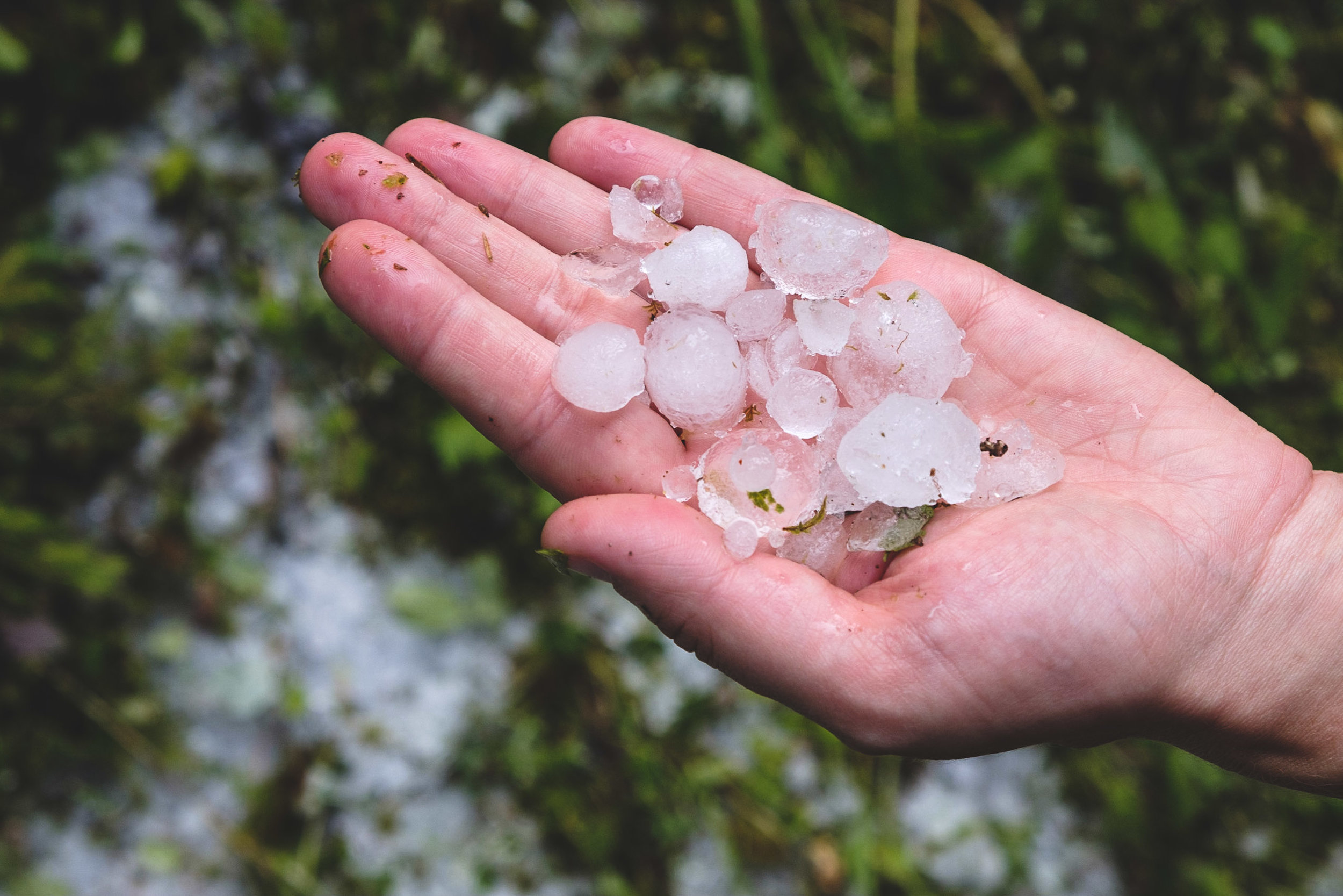
The result of some typical Austrian weather
The trail starts at Sankt Johann in Tyrol and skirts the Wilde Kaiser, a limestone fortress that is heaven for climbers. The main trail runs on the south of the massif, visiting two huts before descending to Kufstein. These huts are very busy and indeed, full when we called them. Instead we took the route on the northern flanks of the massif, taking only two days to cross to Kufstein.

Wilde Kaiser
After the precipitous rock faces of the Wilde Kaiser, the next stage – the Brandenburger alps – is comparably calm. The peaks are relatively low and mostly occupied by livestock farms. This, combined with bad weather, means that we were essentially dragging our boots through liquefied cow shit. The stage ends in a high, on the beautiful Rofan, before taking the cable car down into the valley again.

View from the summit of Rofan
The Rofan is quickly followed by the Karwendel, one of the two main ranges crossed by the Adlerweg. The region is known for its steep passes covered with loose scree, flanked by near-vertical rock faces. Just the thing the doctor ordered! The trail first traverses the northern part of the Karwendel, then joins up with the very popular Traumpfad (dream way) – Munich to Venice – to cross the Birkkarspitze, the highest mountain in the Karwendel. The trail then crosses over to the southern part of the Karwendel, and finally descends into Innsbrück, the largest place and only city visited by the Adlerweg.

View from the Birkkarspitze over the southern Karwendel
After Innsbrück we left the Karwendel and skirted the massif of the Zugspitze, close to the German border. As mentioned, we were stuck in Ehrwald, on the slopes of the Zugspitze, for two days before continuing over the Fernpass into the Lechtaler alps.

This is all we saw of the Zugspitze
The Lechtaler alps consist of beautiful rough terrain with long winding ridges and tricky scrambles. The Lechtaler alps form the second of the main ranges crossed by the Adlerweg. The path roughly follows the watershed until descending into the wintersport village of Sankt Anton am Arlberg. But we don’t want our hike to officially end in a skiing village… Instead, we chose to scramble up the Valluga, on the border of Tyrol and Vorarlberg to finish on a high!
Paths
The Adlerweg is more technical than the GR5 and navigates over trickier scrambles. Nevertheless, the path is generally well maintained and signposted. The tricky bits include the crossing of the Birkkarspitze in the Karwendel, and most of the stages in the Lechtaler alps. On the trickiest sections there are usually fixed cables to aid you. These fixed cables can change a scramble from terrifying to fun and exciting, although in bad weather you should take care with them.

Fixed cables make this section exciting. The tilded camera helps...
Guidebook, maps and signposts
We used the Cicerone guidebook “The Adlerweg” by Mike Wells. This book was published in 2012 and therefore still has the Cicerone “old-style”. While the descriptions and information in the book are generally excellent, the maps in the old-style guidebooks are very rudimentary and can not be relied upon to navigate. You should walk with a proper map anyway. We used 5 sheets of the Freytag & Berndt series of maps (301, 321, 322, 351, 352), which are 1:50.000. Kompass also has a similar series of maps, covering the entire trail in a comparable number of sheets. Kompass 1:50.000 scale maps show more altitude lines than Freytag & Berndt. They also have a 1:25.000 series, which are just enlargements of their 1:50.000 series and show no more detail.
For a while, the Austrian alpine association was in the habit of including many other trails in Tyrol into an Adlerweg network, with the Adlerweg proper running as a backbone between them. This had the consequence that the Adlerweg badge on signposts could be found everywhere, making navigation difficult. The network has since been cleaned up – only a variant in east Tyrol remains. However, on some signposts references to the old Adlerweg-network can still be found, so take care.
Accommodation
We did not bring a tent for this trail, relying instead upon the vast network of mountain huts (Hütte) and Gasthöfe (B&B’s) in Austria. In spite of the name, a hut really is a vast mountain hostel that serves à la carte food and drinks and usually has (paid) hot showers. Bunks include a matrass, pillows and blankets, but you have to bring your own sheet liner.

Leutkircherhütte in the Lechtaler alps
You can get a significant discount at the mountain huts by joining one of the alpine associations. Most of the countries surrounding the alps have a national alpine association, but the Netherlands also has one. These associations band together for the upkeep of the hut network, and consequently, members of any of the associations enjoy a discount, regardless of which association owns the hut. As a member, you also have the right to buy a discounted Bergsteigeressen (mountaineering meal) – usually a simple but filling dish. Finally, should you arrive as a member at a hut that is completely booked, the hut warden is obliged to make room for you. Even though most huts we encountered kept a number of spare beds for such an occasion, we believe that counting on this benefit is rather offensive behaviour towards the hut warden and should only be used in emergencies.
Austria’s Gasthöfe thrive on winter tourism. In the summer season, most of the countries’ Gasthöfe are therefore empty and heavily discounted. If you call the local tourist office (phone numbers are in the guidebooks), they will provide you with the phone numbers of the local Gasthöfe. Most of these seem to be run by somewhat lonely old ladies who love having people over the floor. If you are not careful, they will completely pamper you with food and tea. Finally, many villages give out discount cards for free to people visiting one of the Gasthöfe in summer. These discount cards often include free public transport in the region, or access to the local swimming pools.
For both types of accommodation, it’s a good idea to bring cash as cards are not usually accepted. Calling 2 or 3 days ahead is more than sufficient to find an empty bed in a mountain hut, but even when calling on the same day it is likely you will find a place in a Gasthof.
Food
Tyrolean food is heavy on meat and carbs. Typical recipes are the classical Schnitzel (battered pork), Knödel (filled dumplings), Kaiserschmarrn (eggy, caramelised pancakes) and sausages. In most of the mountain huts the dinner is à la carte. Some huts require you to order your dinner before 5 and serve at a fixed time (make sure you are in the hut by that time!). Most operate like a typical restaurant, though.
All alpine association-owned huts serve Bergsteigeressen, a simple meal similar in style to most Tyrolean food. It will have large quantities of meat and carbs in it, to serve as fuel for next day’s adventure. Sound good? You can only order it when you are a member of any of the alpine associations.
For some reason, Austrians seem to think that vegetarians don’t like food. Spinatknödel (spinach dumpling) is one of the few vegetable dishes and it is usually served without any sides, while the equivalent meat option (Speckknödel or bacon dumpling) is served with a royal helping of Sauerkraut and sausage.
Breakfast is typically a few slices of stale sourdough with marmalade, and a hot drink, all for an outrageously high price. Well. Part of the fun…

A good waterproof coat is no unnecessary luxury...

Gear
As with the GR5, you need the same gear that you take on any mountain hike. Good hiking shoes/boots. Clothes for wet/cold/warm/sunny weather. A hat (to look awesome). Sunscreen. First aid kit. Camera gear. Water and food. Camping gear if you want to camp. A sleeping bag liner (and hut shoes) if you stay in huts. A full gear list will follow soon!